To recap, Ben and I had crossed Thorung La pass (at 5,416 meters / 17,760 feet, the highest point on the Annapurna Circuit) and made our way down (way, way down) to Muktinath. We’d been going pretty hard up until this point of the trek… we hadn’t taken a rest day (and we really only had one easy day) prior to this… so, needless to say, we we’re pretty burnt. We decided to take a whole day off just to relax. Now, I really didn’t expect it, but there was a huge change in the whole atmosphere of the trek once we got over the pass. First off… something you notice right away… is that the scenery changed dramatically. This side of the pass was in the rain shadow of the mountains, so the whole landscape was very dry compared to the other side… it’s looked like a desert surrounded by snow-capped mountains. Another big change that had been noted in our guidebooks was that, in 2008, a road had been built all the way through to Muktinath from parts south (the road had been built over much of the original trekking route, which was simply the walking route between villages, and supposedly “ruined” the back half / descent portion of the circuit). However, the road had some obvious benefits… the lodges in Muktinath were the nicest we had seen along the whole circuit so far (by a long-shot, which is what happens when you can bring in building materials by the truck load instead of the mule load). Now, Muktinath is also a Hindu and Buddhist pilgrimage destination (you can read up on the why here), so the completion of the road has made it much more accessible to Indian tourists. How does this benefit Ben and I you may ask… well, all the Indians means that there’s now Indian food on all of the menus (pretty good Indian food as well), which was a very nice expansion culinary repertoire after days of Nepali Dal Bhat and relatively crappy western food. Another change that didn’t seem obvious at first, but manifested itself later, was that we had crossed from the district of Manang into Lower Mustang (Mustang was an independent Himalayan kingdom until it was absorbed by Nepal in the 18th century). There were subtle differences in the people that I couldn’t really pick up on, but Lower Mustang turned out to just be a much better managed district than pretty much all of the other places we’d been in Nepal… 24 hour electricity, water heaters nearly everywhere, much nicer buildings, better paths, etc… I don’t know if it was just a wealthier place, or a different culture, or what… but hats off to Mustang.

Looking toward Muktinath from the temple grounds…

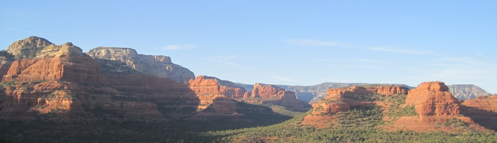
A view towards Upper Mustang past the town of Kagobeni below…

The giant river bed we always seemed to be walking in…

Ben smiling, but secretly despising walking on all the loose rocks (not unlike walking on the beach, so it was tiring… plus the wind… oo la la).
Ben and I spent our day off from trekking exploring Muktinath (we went up to the temple/stupa and a monsastery), running errands (laundry, cleaning, supply re-stocking, etc.) and relaxing (gotta love afternoon naps). The next couple days looked relatively easy on the map as it was pretty much all downhill. The general route was to have us descend from Muktinath into the Gandaki river valley, and then we’d follow the river valley south to a town called Tatopani (descending the whole way), from which we’d then climb back up to a town called Ghorepani and the nearby Poon Hill for some very nice views of the Annapurna Range from the south. The first day out of Muktinath we got a little bit ambitious and aimed for a town called Marpa, which was 26 kilometers away… a pretty long walk for one day, but we figured it was all gradual downhill so it wouldn’t be too bad. Now, based on our guidebook, and our limited road experience on the ascent, we were a bit worried about walking along the road (the road is not a road based on what you’re thinking it is… it’s a one-lane dirt road / rock / gravel road… no pavement)… it’s just no fun having jeeps, buses and trucks honk at you all day while kicking up tons of dust as they rambled by. In general though, we found that it wasn’t as bad as everyone had made it out to be. First off, all the traffic seemed to leave on a schedule (buses and jeeps would leave on the hour), so you’d occasionally get group of jeeps and buses passing, but other than that, there wasn’t more than the occasional motorcycle. Second, the road wasn’t as mountainy or curvy as the road on the other side (it was mostly built into the cliff above the river bed), so there wasn’t the constant honking by every vehicle around all of the blind turns (necessary, but maddening) as there were just less blind turns. So, feeling good about everything, we chugged down the road and into the river bed. That’s when it got a bit… how shall we say… interesting. The river itself was pretty small, but the river bed was a pretty large, flat expanse of gravel and small rocks (about 400 meters wide) , and the trail was such that you walk, more or less, in the river bed… the only problem, was that there was a horrifically strong wind blowing right into our faces as we walked… like a mini-sand blasting for all of your exposed skin (exfoliation… people pay for this?). This continued for the next four or so hours as we made our way to Marpha (once we arrived, we read in our guidebook that this part of the river always gets strong afternoon winds… d’oh). Marpha was a really nice town, built into a hillside with irrigated fields stretching out in front of it. The town council must have passed a resolution because all of the buildings in town were the same color (white paint with red trim), which really made the place look good (another hat tip to the Mustang District). The only not fun moment was after we came back to our room after dinner, we found four giant centipedes just hanging out on the walls of our room (we dispatched them, pulled our beds away from the way, checked our sleeping bags and managed to fall asleep once we were sure none were trying to crawl up on our faces at night). I should have taken a picture, but didn’t think about it (all kill, kill, kill first).

Marpha… land of the giant centipedes… but otherwise a lovely town.

The trail on the other side of the river from the road…

Here’s where we decided to cross the river and get back to the road side…

Ben fording the river (ok, stream)… we had to go back over this again once we saw the bridges…

The bridges we saw after we crossed the river…
Now, to make up a bit for the road, the trail authority had built some trails on the other side of the river from the road. So, when we left Marpha, we decided to try and take the trails as opposed to the road… and the trails were beautiful. However, we found that the trails went up and down and wound their way around much more haphazardly than the relatively straight road. Plus, in addition to being slower, there were no services on that side of the valley (tiny villages, but no restaurants or stores… there was a reason they built the road on one side of the river versus the other). Ben and I decided, at what seemed like an appropriate spot, that we should re-cross the river to the other side (there was a town where we could get lunch). So we made our way into the river bed and managed to ford one of the bigger river branches just fine (shoes and socks off, barefoot crossing across a rocky river bed… but at least they’re round rocks). However, there was a much wider, swifter section of river between us and the town. For some reason, out of the corner of my eye, I noticed some movement, I turned to see, about 400 yards away, a Nepali waving his arms and pointing at something. I turned a bit and looked back up the river bed to see… wait for it (I’m sure you’ll be able to guess)… a small series of log bridges crossing the river. Shyte. Even better, Ben and I were now on an island, so we had to re-ford the river back the way we came to even begin to cross the bridges. Double Shyte. So, with the longer trails and fording and re-fording the river, we managed to turn what should have been an hour and fifteen minute walk into a 3-hour ordeal. Luckily, we stumbled into the best lunch spot/bakery of the entire trek, so that brightened our spirits a bit. Then it was a very, very long afternoon walk into the wind. It was something about this side of the trek (maybe it’s just because we were tired), but all of the towns seemed much farther away than indicated in on our map or in our guidebook… everything just seemed to take longer than it should. For example, the following day we were aiming to have a relatively long day of trekking, which we would end at a town called Rupisahar. The problem came when, after a bit longer and more grueling of a day than we thought it would be, the town that was marked on the map (and on the trail guide the trail authority hands out) didn’t exit (or it existed at some point off the trail and road)… Shyte (again). It was a very long hour until the next town (luckily, by that time, the river canyon had changed directions, so at least there was no more abysmal afternoon headwind to deal with). After three pretty grueling days, we did a short hike into Tatopani to spend the day relaxing at the natural hot springs (which we did… and they were as fantastic as we’d hoped they’d be).

A hot of the other side of the river one afternoon…

We met this one at a rest break…

The worst cheese sandwich ever… who grates cheese for a cold cheese sandwich?

Nice cliff-side trail…

After leaving Mustang one enters the Miyagdi District… proudly “Open Defecation Free.”

A clear mountain stream meeting a muddy one…
On an interesting aside, we had a very good conversation with the Nepali wife who, along with her Dutch husband, ran the really good lunch spot/bakery that Ben and I stumbled into after our river crossing fiasco (The Dutch Bakery in Tukuche… if you’re ever in the neighborhood). They opened their bakery/restaurant/lodge in 1996. At that time there were no roads at all. The wife said that, during high season, about 400 trekkers a day would pass through Tukuche (there’s a permit office in the next village over where all trekkers have to show their trekking permits and they record some information, something Ben and I had to do every couple of days along the circuit… but she could get the relevant numbers). In the early 2000s, the government started work on the road, which was completed in sections, until the whole thing was finished in 2008. She noted that the number of trekkers coming through Tukuche began to decline once the road work began, dropping to 200 a day in the early 2000s, then 100 a day in the mid-2000s… I asked her how many trekkers were coming by a day now? Her answer… 10. So the road has definitely had a huge impact on the number of trekkers on the descent portion of the circuit. Clearly, Ben and I had noticed it. We rarely ran across other people walking, and we saw very few folks in the lodges where we stayed. Most people we had met on the ascent had taken a jeep or a bus from Muktinath down to Tatopani (and the hot springs), or had just simply gone all the way back to Pokhara. On the way up, we noticed that the permit offices put up a couple of charts showing how many trekkers had come through by month and where they were from. On the way up, by far and away the number one source of trekkers was Israel, with the remaining countries rounding out the top 10 being western Europe, the US / Canada and Australia. On the descent though, the number one group was from India, but the trekking guy noted that they were all taking the bus to Muktinath (he said he rarely saw Indians walking). Israelis were no longer the largest non-Indian group (indicating that they generally elected to bus back) and the rest were the same western European, North American and Australian folks, just in much smaller overall numbers. Aside over.

A nice view…

A janky looking bridge…

The endless steps up to Ghorepani (seven hours of this)…
It turned out that we’d needed that day at the hot springs to relax, because the following day was more or less stone steps straight up hill for about seven hours of walking… no, I’m not joking. And somehow, the morning was burning hot, but by noon it had clouded over, and then we ended up climbing the last hour in a hailstorm… so we were very relieved to finally make it to Ghorepani (and to find a place with a nice fire and a hot shower). The village of Ghorepani itself has a decent view of the mountains, but the big attraction in Ghorepani is Poon Hill, a small mountain located just outside of Ghorepani that gives one a clear, nearly 180 degree, view of the Annapurna Range from the south. Now, Ghorepani is at the end of the Annapurna circuit, but there’s also a number of popular, short treks that go through Ghorepani, so the town was quite crowded compared to what Ben and I had experienced in the other towns over the last couple of days (we asked around and that’s when we found out that people were just doing 3-4 day treks to Poon Hill and back). The thing to do at Poon Hill is to watch sunrise over the mountains. Ben and I figured we’d rather sleep in and wait until everyone had come back down… so we went up at 8:30 and had the place pretty much to ourselves (I think still think it was a good decision). We spent the reminder of the day relaxing and planning our next steps.

View from Poon Hill, Annapurna South looks the tallest, but the one to the left is Annapurna I, the 10th highest mountain in the world (8,091 m. / 26,545 ft.)

View from Poon Hill further to the left… Dhauligiri I, the 7th highest mountain in the world (8,167m. / 26,795 ft.)…
Technically, were a day away from being done with the actual Annapurna Circuit, but I wanted to add on a side-trek to Annapurna Base Camp, so I wasn’t done yet. In general, I think Ben and I ended up liking the descent part of the trek better than the ascent. There was less people, fewer Israelis (nice not to have to begin every conversation with “this place is expensive no?”… you’ll know what I’m talking about if you ever travel around/with Isaraelis), I thought the scenery of Lower Mustang was just as good, if not better, than the ascent, as I love that kind of dry-desert with mountains scenery (I’m a Southern Californian… it’s dry with lots of mountains… so maybe it resonates with me somewhat). The lodges, for the most part, were better than the ascent portion (at least in the Mustang District). And walking along the road for large portions were not nearly as bad as the guidebooks made it out to be… plus, if you saw how horrific the shared jeep and bus rides looked (hot, cramped, bumpy and dusty)… you, like us, would have rather walked. A couple of the days on this side were both physically and mentally taxing, but we made up for those days with a bit more rest (we needed it though after walking for so long… maybe our extra tough pace on the front-end was catching up with us bit). So, some totaling through to Ghorepani and Poon Hill.
Days 1-11: 154 kms, +6,690 mts ascent.
Day 12: Chilaxin’ in Muktinath (3,760 mts elevation).
Day 13: Muktinath to Marpa – 26 kms. -1,090 mts descent.
Day 14: Marpa to Kalopani – 18 kms. -140 mts descent.
Day 15: Kalopani to Dana – 16 kms .-890 mts descent.
Day 16: Dana to Tatopani – 8 kms. -250 mts descent.
Day 17: Tatopani to Ghorepani – 17 kms. +1,670 mts ascent.
Day 18: Poon Hill Trek (stayed in Ghorepani again) – 4 kms. +/-330 mts ascent/descent.
Total: 18 days, 243 kilometers (151 miles) and about 8,990 meters of ascending (that’s about 29,500 feet, or 5.6 miles of climbing, which is almost the height of Mt. Everest from sea level).
To be continued…

More Great Read……Thanks Richard for such great pictures and information. Here I am on this great journey in the comfort of my home.
Thank you.
Poon Hill (chuckle)